HimalayanTOPO Nepal Raster US Military 250k
Gallery:


Description
The paper maps of this seamless digital raster map were produced by the US Army Mapping Service (AMS) in 1957 and from around 1983 to 1988 (500k and 001m) and published by the United States Government. These are topographic maps with detailed aeronautical information. Towns, villages, pipelines, roads, railroads and similar cultural information are also indicated. While the street layer is completely out of date due to the age of the maps, the topographic details have a very high accuracy. The map has cyrillic labels only. Please note that all height data is in feet.
The map is compatible with all major GIS software products like QuoVadis® or Global Mapper®. A detailed DEM (Digital Elevation Model) is included to view the map in 3D mode (functionality depends on your GPS software).
The mapset includes (seamless):
- US Military Map in 250k (1:250.000)
- US Military Map in 500k (1:500.000)
- US Military Map in 001m (1:1.000.000)
- Digital Elevation Model
Compatibility
- QuoVadis®
- GlobalMapper®
- OziExplorer®
- Many more with GeoTiff®- and ECW®-Support
Data format
The package contains the seamless raster map as well as the Digital Elevation Model. The following file formats are included:
- Soviet Military Map: ECW® (.ecw format). best for QuoVadis® (newer versions) and OziExplorer® and GeoTIFF® (.tiff format), best for Global Mapper®
- Digital Elevation Model: Global Mapper® Grid (.gmg format), best for Global Mapper® and QuoVadis®, and GeoTIFF®, GeoTIFF® (.tiff format), SRTM3 (.hgt format)
Map Coverage
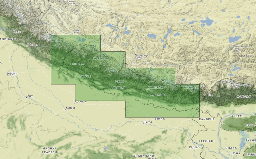
The map covers Nepal in total.
Datasource
The basis are the US military maps created 1956 (250k), and between 1983 and 1988 (500k, 001m) by the U.S. Army Map Service (AMS) and the follow up organizations. These maps were enhanced with hill shading by HimalayanGPSMaps in 2019.
The basis of our Digital Elevation Model is the 3 arc seconds data set collected by the 2000 Shuttle Radar Topography mission (NASA/USGS SRTM3). This data was enhanced and corrected by Jonathan de Ferranti from Viewfinder Panoramas with other topographic sources like raster and paper maps. Therefore the data from Viewfinder Panoramas is the best DEM data available for the Himalaya region. The data from Viewfinder Panoramas was slighty corrected and enhanced by HimalayanGPSMaps in 2016.
“The cartographic production produced by the USSR during the Cold War period is immense, encompassing all corners of the globe. These topographic maps have a quality and a detail that surprises, especially as some of them are so remote and difficult to access for the technology of the time. Today, we can find countries where the best cartographic base is even Soviet maps.“
https://www.geamap.com/en/soviet